
8/14/2014. Merced, California.
We would like to announce our successful flights of missions today at Vernal Pool and Grassland Reserve, UC Merced's scientific data-drone flight test site approved by FAA under COA-2014-WSA-29 (PDF).
The most interesting features of these history making flights are
- Multispectral imaging at TIR (thermal infrared 7-14 um) and SWIR (short-wave infrared 0.9-1.7 um) ranges at affordable costs. (IR cameras are from ICI)
- Cameras with RGB, NIR (near infrared), TIR, and SWIR are easily reconfigured into payload box with desirable combinations of bands, a step towards our long term vision shown in this paper [1].
- Cost and reliability/repeatability - unbeatable at UC Merced!
Here are some snapshots: (Click here for additional pics/movies). So, are we entering into the era of "Personal LandSat" or "LandSat-XP" (XP: extremely personal)?
Two thermal IR (TIR) photos from the data-drone:
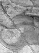

(Note: road, field, gravel, pond, trees are in different temperature)
Two short-wave IR (SWIR) photos from the data-drone:
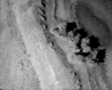
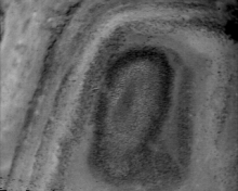
(Note: Dried ponds show clear moisture contours NOT seen from visual and NIR imagery)
More updates/pictures.
Page created by Professor YangQuan Chen. (Email me if you are curious why I feel so excited and why it is historical)
Crew credentials: Brandon Stark, Brendan Smith, Yoni and Andy. Dr. Chen checked ground temerature and recorded landings. It was 127 F!)
Acknowledgements: ICI Gary Strahan, Abhishek Madaan, Gary Forister. UCM CITRIS Josh Viers. AggieAir.
[1]. Haiyang Chao+, Marc Baumann+, Austin Jensens+, YangQuan Chen*, Yongcan Cao, Wei Ren and Mac McKee. Band-reconfigurable Multi-UAV-based Cooperative Remote Sensing for Real-time Water Management and Distributed Irrigation Control. In Proceedings of the IFAC World Congress, Seoul, Korea, July 2008


